NASA launches International SWOT mission to survey Earth's water...
...and the Agency is also developing AI method to navigate the lunar surface.
20 December 2022 Photonics World
 A satellite built for NASA and the French space agency Centre National d'Études Spatiales (CNES) to observe nearly all the water on our planet's surface lifted off on its way to low-Earth orbit at 3:46 a.m. PST on December 16th. The Surface Water and Ocean Topography (SWOT) spacecraft also has contributions from the Canadian Space Agency (CSA) and the UK Space Agency.
The SWOT spacecraft launched on a SpaceX rocket from Space Launch Complex 4E at Vandenberg Space Force Base in California with a prime mission of three years. The satellite will measure the height of water in freshwater bodies and the ocean on more than 90 percent of Earth's surface. This information will provide insights into how the ocean influences climate change; how a warming world affects lakes, rivers, and reservoirs; and how communities can better prepare for disasters, such as floods.
"Warming seas, extreme weather, more severe wildfires - these are only some of the consequences humanity is facing due to climate change," commented NASA Administrator Bill Nelson. "The climate crisis requires an all-hands-on-deck approach, and SWOT is the realization of a long-standing international partnership that will ultimately better equip communities so that they can face these challenges."
'Terabit of data per day'
SWOT will cover the entire Earth's surface between 78 degrees south and 78 degrees north latitude at least once every 21 days, sending back about one terabyte of unprocessed data per day. The scientific heart of the spacecraft is an innovative instrument called the Ka-band radar interferometer (KaRIn), which marks a major technological advance.
KaRIn bounces radar pulses off the water's surface and receives the return signal using two antennas on either side of the spacecraft. This arrangement - one signal, two antennas - will enable engineers to precisely determine the height of the water's surface across two swaths at a time, each of them 50 kilometers wide.
 "We're eager to see SWOT in action," said Karen St. Germain, NASA Earth Science Division director. "This satellite embodies how we are improving life on Earth through science and technological innovations. The data that innovation will provide is essential to better understanding how Earth's air, water, and ecosystems interact - and how people can thrive on our changing planet."
Among the many benefits the SWOT mission will provide is a significantly clearer picture of Earth's freshwater bodies. It will provide data on more than 95% of the world's lakes larger than 15 acres (62,500 square meters) and rivers wider than 330 feet (100 meters) across. Currently, freshwater researchers have reliable measurements for only a few thousand lakes around the world. SWOT will push that number into the millions.
Such an ambitious mission is possible because of NASA's long-standing commitment to working with agencies around the world to study Earth and its climate. NASA and CNES have built upon a decades-long relationship that started in the 1980s to monitor Earth's oceans. This collaboration pioneered the use of a space-based altimeter to study sea level with the launch of the TOPEX/Poseidon satellite in 1992.
"SWOT will provide vital information, given the urgent challenges posed by climate change and sea level rise," said Laurie Leshin, NASA's Jet Propulsion Laboratory (JPL) director. JPL developed the KaRIn instrument and manages the U.S. portion of the mission. "That SWOT will fill gaps in our knowledge and inform future action is the direct result of commitment, innovation, and collaboration going back many years. We're excited to get SWOT science underway," said Leshin.
 NASA developing AI to navigate lunar surface
A NASA engineer is teaching a machine to use features on the Moon's horizon to navigate across the lunar surface. "For safety and science geotagging, it's important for explorers to know exactly where they are as they explore the lunar landscape," said Alvin Yew, a research engineer at NASA's Goddard Space Flight Center in Greenbelt, Maryland.
NASA is currently working with industry and other international agencies to develop a communications and navigation architecture for the moon. LunaNet will bring "internet-like" capabilities to the moon, including location services. However, explorers in some regions on the lunar surface may require overlapping solutions derived from multiple sources to assure safety should communication signals not be available.
Yew said, "The motivation for me was to enable lunar crater exploration, where the entire horizon would be the crater rim." Yew started with data from NASA's Lunar Reconnaissance Orbiter, specifically the Lunar Orbiter Laser Altimeter (LOLA). LOLA measures slopes, lunar surface roughness, and generates high resolution topographic maps of the moon.
Yew is training an artificial intelligence system to recreate features on the lunar horizon as they would appear to an explorer on the lunar surface using LOLA's digital elevation models. Those digital panoramas can be used to correlate known boulders and ridges with those visible in pictures taken by a rover or astronaut, providing accurate location identification for any given region.

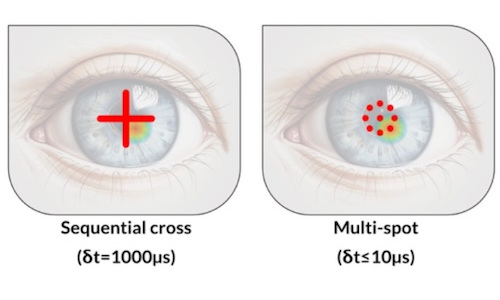
Multi-spot OCT tracks cornea deformations
July 29 2026


Gooch & Housego poised for private equity buyout
July 29 2026