NASA's 3D wind measuring laser aims to improve weather forecasts...
...while ESA launches Biomass satellite to determine world's forest carbon profile.
29 April 2025 Photonics Applications News
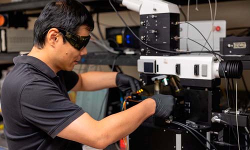
 Since fall 2024, NASA scientists have flown a 3D Doppler wind lidar instrument across the United States to collect nearly 100 hours of atmospheric data - including through a hurricane. The goal is to demonstrate the capability of the Aerosol Wind Profiler (AWP) instrument to gather precise measurements of wind direction, wind speed, and aerosol concentration - with the purpose of making more accurate weather forecasts.
"There is a lack of global wind measurements above Earth's surface," said Kris Bedka, the AWP principal investigator at NASA's Langley Research Center in Hampton, Virginia. "Winds are measured by commercial aircraft as they fly to their destinations and by weather balloons launched up to twice per day from just 1,300 sites across the globe. From space, winds are estimated by tracking cloud and water vapor movement from satellite images."
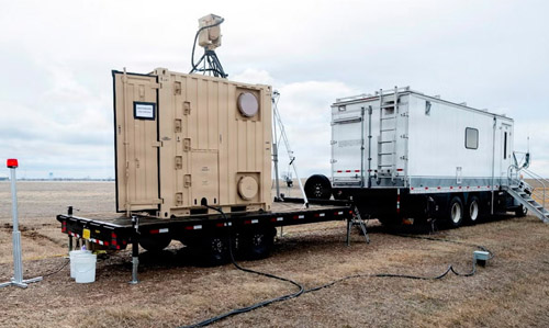
However, in areas without clouds or where water vapor patterns cannot be easily tracked, there are typically no reliable wind measurements. The AWP instrument seeks to fill these gaps. Mounted on an aircraft with viewing ports beneath, the AWP emits 200 laser pulses per second that scatter and reflect off aerosol particles. Particle movements causes the laser pulse wavelength to change according to the Doppler effect.
Different altitudes
"The AWP measures wind speed and direction, but not just at one point," Bedka said. "Instead, we are measuring winds at different altitudes in the atmosphere simultaneously with high accuracy."
Vectors help researchers and meteorologists understand the weather, so AWP's measurements could significantly advance weather modeling and forecasting. For this reason, the instrument was chosen to be part of the National Oceanic and Atmospheric Administration's (NOAA) Joint Venture Program. NASA's Weather Program also saw mutual benefit in NOAA's investments and provided additional support to increase the return on investment for both agencies. On board NASA's Gulfstream III aircraft, AWP was paired with the agency's High-Altitude Lidar Observatory (HALO) that measures water vapor, aerosols, and cloud properties through a combined differential absorption and high spectral resolution lidar.
Working together for the first time, AWP measured winds, HALO collected water vapor and aerosol data, and NOAA dropsondes (small instruments dropped from a tube in the bottom of the aircraft) gathered temperature, water vapor, and wind data. Bedka added, "The combination of AWP and HALO is NASA's next-generation airborne weather remote sensing package, which we hope to also fly aboard satellites to benefit everyone across the globe."
During the joint venture flights, Hurricane Helene was making landfall in Florida. The AWP crew of two pilots and five science team members quickly created a flight plan to gather wind measurements along the outer bands of the severe storm. "A 3D wind profile can significantly improve weather forecasts, particularly for storms and hurricanes," said Harshesh Patel, NOAA's acting Joint Venture Program manager. "NASA Langley specializes in the development of coherent Doppler wind lidar technology and this AWP concept has potential to provide better performance for NOAA's needs."
After the NOAA flights, AWP and HALO were sent to central California for the Westcoast & Heartland Hyperspectral Microwave Sensor Intensive Experiment and the Active Passive profiling Experiment, which was supported by NASA's Planetary Boundary Layer Decadal Survey Incubation Program and NASA Weather Programs. These missions studied atmospheric processes within the planetary boundary layer, the lowest part of the atmosphere, that drives the weather conditions we experience on the ground.
 ESA launches Biomass satellite to measure forest carbon
The European Space Agency's (ESA) Biomass satellite, designed to provide insights into the world's forests and their vital role in Earth's carbon cycle, has been launched. The satellite lifted off aboard a Vega-C rocket from Europe's Spaceport in Kourou, French Guiana, on 29th April.
Less than an hour after launch, Biomass separated from the rocket's upper stage. The satellite controllers at ESA's European Space Operations Centre in Germany soon received the first signal, relayed via the Troll ground station in Antarctica, confirming that Biomass is "working as expected in orbit", said an ESA statement.
Controllers are set to spend the following days carrying out the "launch and early orbit" phases, to verify that all systems are functioning correctly. This critical phase also involves a series of intricate manoeuvres to deploy the satellite's 12 m-wide mesh reflector supported by a 7.5 m boom. Once this phase is complete, Biomass will join the portfolio of pioneering missions operated from ESA's mission control center.
Carrying the first "P-band" synthetic aperture radar in space, the Biomass mission is designed to deliver crucial information about the state of Earth's forests and how they are changing, and to further knowledge of the role forests play in the carbon cycle. P-band frequencies lie between 0.3 and 1 GHz, corresponding to wavelengths between 30 and 100 cm.
 'Filling knowledge gaps'
ESA's Director of Earth Observation Programmes, Simonetta Cheli, said, "Congratulations to everyone who has been involved in developing and launching this extraordinary mission. Biomass now joins our family of Earth Explorers - missions that have consistently delivered groundbreaking discoveries and advanced scientific understanding of our planet.
"With Biomass, we are poised to gain vital new data on how much carbon is stored in the world's forests, helping to fill key gaps in our knowledge of the carbon cycle and, ultimately, Earth's climate system."
Biomass is the first satellite equipped with a P-band synthetic aperture radar, which is capable of penetrating forest canopies to measure woody biomass - trunks, branches, and stems - where most forest carbon is stored. These measurements act as a proxy for carbon storage, the assessment of which is the mission's primary goal.
ESA stated that data from Biomass "will significantly reduce uncertainties in carbon stock and flux estimates, including those related to land-use change, forest loss, and regrowth."
Multi-spot OCT tracks cornea deformations
July 29 2026
Gooch & Housego poised for private equity buyout
July 29 2026